Land that is registered with The Property Registration Authority is recorded on a central mapping database, and land to be newly registered must be mapped in accordance with strict PRAI rules. So once a parcel of land is registered, there is a grid-referenced digital record of its outline on current Ordnance Survey mapping.
Much of Ireland’s land is unregistered title; these records are held with the Registry of Deeds and the associated deed maps are of varying, often poor, quality.
When purchasing property, it’s important to understand what type of title is associated with that property, and also to verify whether the physical boundaries are accurately represented by the title mapping. A boundary survey and review of associated mapping can highlight issues with the title before contracts are signed.
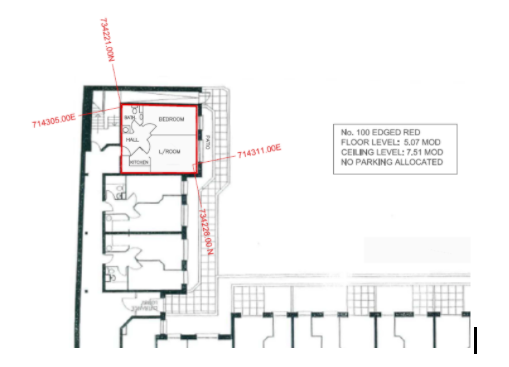
When a property is changing hands, suitable mapping for conveyancing and registration must be produced. In the case of a land parcel (e.g. house and gardens), this is a land registry compliant map which shows the parcel boundaries on the current Ordnance Survey map. Where an apartment is being sold, mapping must be produced that shows the location of the block, and also the location of the apartment within that block. To accurately represent the 3D space occupied by the apartment, it’s necessary to show coordinate information in plan to give the horizontal location, and the floor level and ceiling level to give the vertical location. PRAI guidelines for multi-storey registration apply in the case of apartment registration.
 In the case of larger land parcels, especially in urban areas, the title may be a made up of numerous maps of varying qualities, reference systems, accuracies and scales. For this type of site, it’s recommended to produce a composite map showing how all the associated mapping correlates. This allows any gaps in the title to be identified, and also any conflicts with adjoining land parcels.
Where all the units in a new housing development are to be registered, this can be done as a scheme map rather than individually. This is relatively straight forward for a new development as there are no legacy issues with individual plot boundaries. Common areas will often be registered to a management company or taken in charge by the local authority.
Registration Related Services
- Boundary Verification
- Conveyance Maps
- Land Registry Compliant Maps
- Composite Maps/Overlays
- Scheme Maps
- Multi-storey registrations